|
|
|||||||||||||||||
| Point ID: 8195 | Downloads | Plots | Site Data | Code: 8190 |
|
|
|||||||||||||||||
| Download | |
|---|---|
| Site Descriptor Information | Site Time Series Data |
| Link to all available data | |
| View: | Time Series | All |
| Units: | mm |
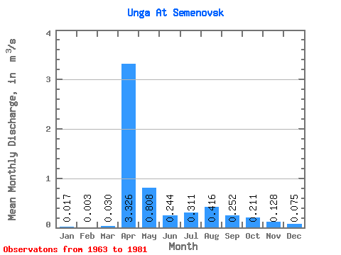
| Statistic | Jan | Feb | Mar | Apr | May | Jun | Jul | Aug | Sep | Oct | Nov | Dec | Annual |
|---|---|---|---|---|---|---|---|---|---|---|---|---|---|
| Mean | 0.02 | 0.00 | 0.03 | 3.33 | 0.81 | 0.24 | 0.31 | 0.42 | 0.25 | 0.21 | 0.13 | 0.07 | 0.48 |
| Standard Deviation | 0.03 | 0.01 | 0.08 | 3.40 | 0.71 | 0.08 | 0.18 | 0.32 | 0.15 | 0.09 | 0.07 | 0.05 | 0.34 |
| Min | 0.00 | 0.00 | 0.00 | 0.19 | 0.16 | 0.14 | 0.09 | 0.13 | 0.13 | 0.12 | 0.05 | 0.01 | 0.12 |
| Max | 0.08 | 0.06 | 0.27 | 15.40 | 2.66 | 0.37 | 0.85 | 1.05 | 0.67 | 0.37 | 0.29 | 0.21 | 1.61 |
| Coefficient of Variation | 1.60 | 4.03 | 2.56 | 1.02 | 0.88 | 0.32 | 0.57 | 0.78 | 0.59 | 0.42 | 0.56 | 0.66 | 0.70 |
 Return to R-Arctic Net Home Page