|
|
|||||||||||||||||
| Point ID: 8195 | Downloads | Plots | Site Data | Code: 8190 |
|
|
|||||||||||||||||
| Download | |
|---|---|
| Site Descriptor Information | Site Time Series Data |
| Link to all available data | |
| View: | Time Series | All |
| Units: | m3/s |
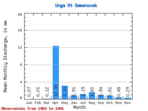
| Statistic | Jan | Feb | Mar | Apr | May | Jun | Jul | Aug | Sep | Oct | Nov | Dec | Annual |
|---|---|---|---|---|---|---|---|---|---|---|---|---|---|
| Mean | 0.07 | 0.01 | 0.12 | 12.35 | 3.10 | 0.91 | 1.19 | 1.59 | 0.94 | 0.81 | 0.47 | 0.29 | 21.84 |
| Standard Deviation | 0.11 | 0.05 | 0.30 | 12.62 | 2.71 | 0.29 | 0.68 | 1.24 | 0.55 | 0.34 | 0.27 | 0.19 | 15.28 |
| Min | 0.00 | 0.00 | 0.00 | 0.71 | 0.61 | 0.52 | 0.34 | 0.50 | 0.48 | 0.46 | 0.17 | 0.05 | 5.47 |
| Max | 0.32 | 0.20 | 1.04 | 57.19 | 10.21 | 1.37 | 3.26 | 4.03 | 2.49 | 1.42 | 1.08 | 0.81 | 72.61 |
| Coefficient of Variation | 1.60 | 4.03 | 2.56 | 1.02 | 0.88 | 0.32 | 0.57 | 0.78 | 0.59 | 0.42 | 0.56 | 0.66 | 0.70 |
 Return to R-Arctic Net Home Page