|
|
|||||||||||||||||
| Point ID: 8182 | Downloads | Plots | Site Data | Code: 8157 |
|
|
|||||||||||||||||
| Download | |
|---|---|
| Site Descriptor Information | Site Time Series Data |
| Link to all available data | |
| View: | Time Series | All |
| Units: | mm |
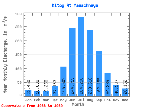
| Statistic | Jan | Feb | Mar | Apr | May | Jun | Jul | Aug | Sep | Oct | Nov | Dec | Annual |
|---|---|---|---|---|---|---|---|---|---|---|---|---|---|
| Mean | 22.45 | 18.69 | 19.26 | 37.16 | 106.61 | 244.72 | 284.29 | 238.52 | 162.16 | 84.24 | 40.59 | 28.15 | 107.74 |
| Standard Deviation | 4.38 | 3.96 | 3.99 | 9.05 | 32.58 | 86.27 | 111.57 | 71.62 | 44.14 | 16.32 | 7.06 | 4.96 | 19.26 |
| Min | 13.60 | 9.53 | 8.44 | 19.60 | 36.90 | 137.00 | 164.00 | 152.00 | 93.80 | 56.90 | 27.40 | 18.90 | 77.50 |
| Max | 31.90 | 27.00 | 25.50 | 55.40 | 195.00 | 498.00 | 640.00 | 429.00 | 263.00 | 123.00 | 57.30 | 39.20 | 153.41 |
| Coefficient of Variation | 0.20 | 0.21 | 0.21 | 0.24 | 0.31 | 0.35 | 0.39 | 0.30 | 0.27 | 0.19 | 0.17 | 0.18 | 0.18 |
 Return to R-Arctic Net Home Page