|
|
|||||||||||||||||
| Point ID: 8182 | Downloads | Plots | Site Data | Code: 8157 |
|
|
|||||||||||||||||
| Download | |
|---|---|
| Site Descriptor Information | Site Time Series Data |
| Link to all available data | |
| View: | Time Series | All |
| Units: | m3/s |
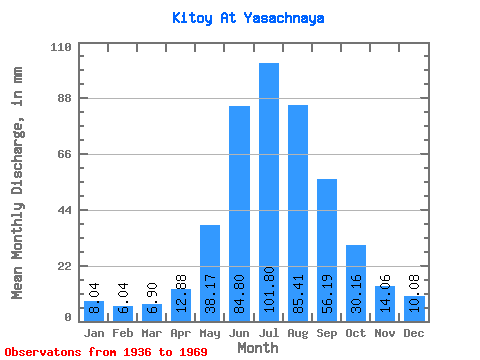
| Statistic | Jan | Feb | Mar | Apr | May | Jun | Jul | Aug | Sep | Oct | Nov | Dec | Annual |
|---|---|---|---|---|---|---|---|---|---|---|---|---|---|
| Mean | 8.04 | 6.10 | 6.89 | 12.88 | 38.17 | 84.80 | 101.78 | 85.39 | 56.19 | 30.16 | 14.06 | 10.08 | 454.58 |
| Standard Deviation | 1.57 | 1.29 | 1.43 | 3.14 | 11.66 | 29.89 | 39.95 | 25.64 | 15.29 | 5.84 | 2.44 | 1.77 | 81.26 |
| Min | 4.87 | 3.11 | 3.02 | 6.79 | 13.21 | 47.47 | 58.72 | 54.42 | 32.50 | 20.37 | 9.49 | 6.77 | 326.99 |
| Max | 11.42 | 8.81 | 9.13 | 19.20 | 69.81 | 172.57 | 229.13 | 153.59 | 91.14 | 44.04 | 19.86 | 14.03 | 647.27 |
| Coefficient of Variation | 0.20 | 0.21 | 0.21 | 0.24 | 0.31 | 0.35 | 0.39 | 0.30 | 0.27 | 0.19 | 0.17 | 0.18 | 0.18 |
 Return to R-Arctic Net Home Page