|
|
|||||||||||||||||
| Point ID: 8168 | Downloads | Plots | Site Data | Code: 8129 |
|
|
|||||||||||||||||
| Download | |
|---|---|
| Site Descriptor Information | Site Time Series Data |
| Link to all available data | |
| View: | Time Series | All |
| Units: | mm |
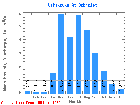
| Statistic | Jan | Feb | Mar | Apr | May | Jun | Jul | Aug | Sep | Oct | Nov | Dec | Annual |
|---|---|---|---|---|---|---|---|---|---|---|---|---|---|
| Mean | 0.22 | 0.15 | 0.11 | 1.55 | 5.87 | 4.19 | 5.82 | 4.67 | 3.04 | 1.70 | 0.74 | 0.37 | 2.38 |
| Standard Deviation | 0.10 | 0.07 | 0.06 | 1.47 | 3.39 | 3.02 | 5.13 | 3.53 | 2.17 | 0.92 | 0.45 | 0.20 | 0.88 |
| Min | 0.04 | 0.04 | 0.03 | 0.11 | 0.99 | 0.96 | 1.11 | 0.87 | 0.51 | 0.35 | 0.14 | 0.07 | 0.88 |
| Max | 0.45 | 0.28 | 0.29 | 5.93 | 14.10 | 17.20 | 23.10 | 14.20 | 9.12 | 3.94 | 1.86 | 0.88 | 4.50 |
| Coefficient of Variation | 0.47 | 0.48 | 0.51 | 0.95 | 0.58 | 0.72 | 0.88 | 0.76 | 0.71 | 0.54 | 0.61 | 0.54 | 0.37 |
 Return to R-Arctic Net Home Page