|
|
|||||||||||||||||
| Point ID: 8168 | Downloads | Plots | Site Data | Code: 8129 |
|
|
|||||||||||||||||
| Download | |
|---|---|
| Site Descriptor Information | Site Time Series Data |
| Link to all available data | |
| View: | Time Series | All |
| Units: | m3/s |
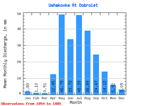
| Statistic | Jan | Feb | Mar | Apr | May | Jun | Jul | Aug | Sep | Oct | Nov | Dec | Annual |
|---|---|---|---|---|---|---|---|---|---|---|---|---|---|
| Mean | 1.80 | 1.10 | 0.90 | 12.46 | 48.79 | 33.73 | 48.38 | 38.88 | 24.47 | 14.11 | 5.92 | 3.10 | 232.88 |
| Standard Deviation | 0.85 | 0.53 | 0.46 | 11.87 | 28.23 | 24.35 | 42.67 | 29.36 | 17.49 | 7.62 | 3.63 | 1.66 | 86.62 |
| Min | 0.32 | 0.27 | 0.27 | 0.89 | 8.23 | 7.73 | 9.23 | 7.24 | 4.11 | 2.91 | 1.13 | 0.55 | 85.92 |
| Max | 3.74 | 2.12 | 2.41 | 47.73 | 117.27 | 138.46 | 192.12 | 118.10 | 73.41 | 32.77 | 14.97 | 7.32 | 441.37 |
| Coefficient of Variation | 0.47 | 0.48 | 0.51 | 0.95 | 0.58 | 0.72 | 0.88 | 0.76 | 0.71 | 0.54 | 0.61 | 0.54 | 0.37 |
 Return to R-Arctic Net Home Page