|
|
|||||||||||||||||
| Point ID: 8163 | Downloads | Plots | Site Data | Code: 8118 |
|
|
|||||||||||||||||
| Download | |
|---|---|
| Site Descriptor Information | Site Time Series Data |
| Link to all available data | |
| View: | Time Series | All |
| Units: | mm |
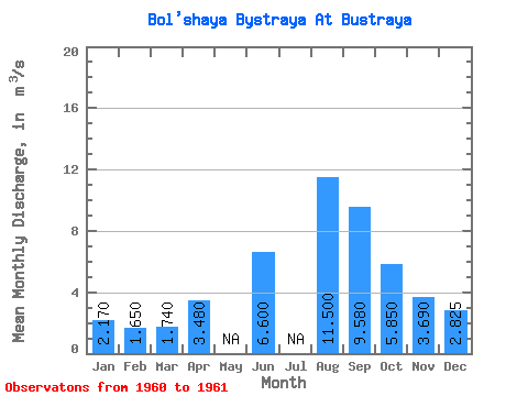
| Statistic | Jan | Feb | Mar | Apr | May | Jun | Jul | Aug | Sep | Oct | Nov | Dec | Annual |
|---|---|---|---|---|---|---|---|---|---|---|---|---|---|
| Mean | 2.17 | 1.65 | 1.74 | 3.48 | 6.60 | 11.50 | 9.58 | 5.85 | 3.69 | 2.83 | |||
| Standard Deviation | 0.38 | 0.11 | |||||||||||
| Min | 2.17 | 1.65 | 1.74 | 3.48 | 6.60 | 11.50 | 9.58 | 5.85 | 3.42 | 2.75 | |||
| Max | 2.17 | 1.65 | 1.74 | 3.48 | 6.60 | 11.50 | 9.58 | 5.85 | 3.96 | 2.90 | |||
| Coefficient of Variation | 0.10 | 0.04 |
 Return to R-Arctic Net Home Page