|
|
|||||||||||||||||
| Point ID: 8163 | Downloads | Plots | Site Data | Code: 8118 |
|
|
|||||||||||||||||
| Download | |
|---|---|
| Site Descriptor Information | Site Time Series Data |
| Link to all available data | |
| View: | Time Series | All |
| Units: | m3/s |
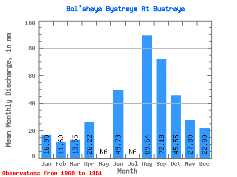
| Statistic | Jan | Feb | Mar | Apr | May | Jun | Jul | Aug | Sep | Oct | Nov | Dec | Annual |
|---|---|---|---|---|---|---|---|---|---|---|---|---|---|
| Mean | 16.89 | 11.70 | 13.55 | 26.22 | 49.73 | 89.53 | 72.18 | 45.54 | 27.80 | 21.99 | |||
| Standard Deviation | 2.88 | 0.83 | |||||||||||
| Min | 16.89 | 11.70 | 13.55 | 26.22 | 49.73 | 89.53 | 72.18 | 45.54 | 25.77 | 21.41 | |||
| Max | 16.89 | 11.70 | 13.55 | 26.22 | 49.73 | 89.53 | 72.18 | 45.54 | 29.84 | 22.58 | |||
| Coefficient of Variation | 0.10 | 0.04 |
 Return to R-Arctic Net Home Page