|
|
|||||||||||||||||
| Point ID: 8146 | Downloads | Plots | Site Data | Code: 8008 |
|
|
|||||||||||||||||
| Download | |
|---|---|
| Site Descriptor Information | Site Time Series Data |
| Link to all available data | |
| View: | Time Series | All |
| Units: | mm |
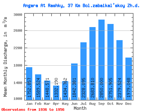
| Statistic | Jan | Feb | Mar | Apr | May | Jun | Jul | Aug | Sep | Oct | Nov | Dec | Annual |
|---|---|---|---|---|---|---|---|---|---|---|---|---|---|
| Mean | 1752.86 | 1589.52 | 1448.57 | 1332.19 | 1434.76 | 1842.38 | 2328.09 | 2683.81 | 2850.00 | 2751.91 | 2379.52 | 1979.05 | 2031.06 |
| Standard Deviation | 302.48 | 245.02 | 207.73 | 193.04 | 204.95 | 271.90 | 365.82 | 383.32 | 441.19 | 461.31 | 415.38 | 348.11 | 266.97 |
| Min | 1150.00 | 1140.00 | 1040.00 | 996.00 | 1090.00 | 1350.00 | 1770.00 | 2120.00 | 2110.00 | 1940.00 | 1690.00 | 1370.00 | 1539.17 |
| Max | 2470.00 | 2130.00 | 1910.00 | 1790.00 | 1920.00 | 2310.00 | 3130.00 | 3540.00 | 3830.00 | 3900.00 | 3460.00 | 2840.00 | 2626.67 |
| Coefficient of Variation | 0.17 | 0.15 | 0.14 | 0.14 | 0.14 | 0.15 | 0.16 | 0.14 | 0.15 | 0.17 | 0.17 | 0.18 | 0.13 |
 Return to R-Arctic Net Home Page