|
|
|||||||||||||||||
| Point ID: 8146 | Downloads | Plots | Site Data | Code: 8008 |
|
|
|||||||||||||||||
| Download | |
|---|---|
| Site Descriptor Information | Site Time Series Data |
| Link to all available data | |
| View: | Time Series | All |
| Units: | m3/s |
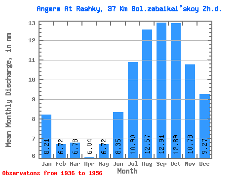
| Statistic | Jan | Feb | Mar | Apr | May | Jun | Jul | Aug | Sep | Oct | Nov | Dec | Annual |
|---|---|---|---|---|---|---|---|---|---|---|---|---|---|
| Mean | 8.21 | 6.78 | 6.78 | 6.04 | 6.72 | 8.35 | 10.90 | 12.56 | 12.91 | 12.88 | 10.78 | 9.27 | 112.06 |
| Standard Deviation | 1.42 | 1.04 | 0.97 | 0.88 | 0.96 | 1.23 | 1.71 | 1.79 | 2.00 | 2.16 | 1.88 | 1.63 | 14.73 |
| Min | 5.38 | 4.86 | 4.87 | 4.51 | 5.10 | 6.12 | 8.29 | 9.93 | 9.56 | 9.08 | 7.66 | 6.41 | 84.92 |
| Max | 11.56 | 9.09 | 8.94 | 8.11 | 8.99 | 10.47 | 14.65 | 16.57 | 17.36 | 18.26 | 15.68 | 13.30 | 144.93 |
| Coefficient of Variation | 0.17 | 0.15 | 0.14 | 0.14 | 0.14 | 0.15 | 0.16 | 0.14 | 0.15 | 0.17 | 0.17 | 0.18 | 0.13 |
 Return to R-Arctic Net Home Page