|
|
|||||||||||||||||
| Point ID: 8142 | Downloads | Plots | Site Data | Code: 7197 |
|
|
|||||||||||||||||
| Download | |
|---|---|
| Site Descriptor Information | Site Time Series Data |
| Link to all available data | |
| View: | Time Series | All |
| Units: | mm |
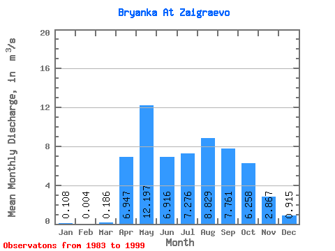
| Statistic | Jan | Feb | Mar | Apr | May | Jun | Jul | Aug | Sep | Oct | Nov | Dec | Annual |
|---|---|---|---|---|---|---|---|---|---|---|---|---|---|
| Mean | 0.11 | 0.00 | 0.19 | 6.95 | 12.20 | 6.92 | 7.28 | 8.83 | 7.76 | 6.26 | 2.87 | 0.92 | 4.53 |
| Standard Deviation | 0.14 | 0.01 | 0.30 | 3.00 | 5.48 | 2.87 | 3.12 | 4.52 | 3.07 | 2.71 | 1.13 | 0.65 | 0.76 |
| Min | 0.00 | 0.00 | 0.00 | 2.12 | 5.06 | 3.85 | 3.53 | 3.98 | 3.62 | 3.26 | 1.06 | 0.08 | 4.01 |
| Max | 0.47 | 0.01 | 0.98 | 12.80 | 21.10 | 15.10 | 15.10 | 22.20 | 16.90 | 15.30 | 4.72 | 2.57 | 5.39 |
| Coefficient of Variation | 1.33 | 2.00 | 1.65 | 0.43 | 0.45 | 0.41 | 0.43 | 0.51 | 0.40 | 0.43 | 0.40 | 0.71 | 0.17 |
 Return to R-Arctic Net Home Page