|
|
|||||||||||||||||
| Point ID: 8142 | Downloads | Plots | Site Data | Code: 7197 |
|
|
|||||||||||||||||
| Download | |
|---|---|
| Site Descriptor Information | Site Time Series Data |
| Link to all available data | |
| View: | Time Series | All |
| Units: | m3/s |
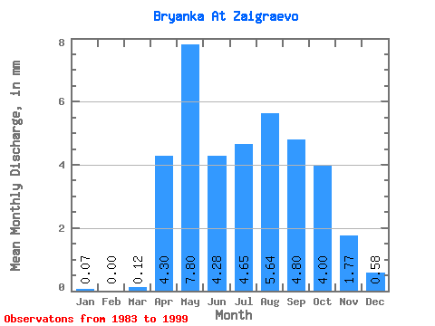
| Statistic | Jan | Feb | Mar | Apr | May | Jun | Jul | Aug | Sep | Oct | Nov | Dec | Annual |
|---|---|---|---|---|---|---|---|---|---|---|---|---|---|
| Mean | 0.07 | 0.00 | 0.12 | 4.30 | 7.80 | 4.28 | 4.65 | 5.64 | 4.80 | 4.00 | 1.77 | 0.58 | 34.11 |
| Standard Deviation | 0.09 | 0.00 | 0.20 | 1.85 | 3.50 | 1.77 | 2.00 | 2.89 | 1.90 | 1.73 | 0.70 | 0.41 | 5.68 |
| Min | 0.00 | 0.00 | 0.00 | 1.31 | 3.23 | 2.38 | 2.26 | 2.54 | 2.24 | 2.08 | 0.66 | 0.05 | 30.24 |
| Max | 0.30 | 0.01 | 0.63 | 7.92 | 13.49 | 9.34 | 9.65 | 14.19 | 10.46 | 9.78 | 2.92 | 1.64 | 40.64 |
| Coefficient of Variation | 1.33 | 2.00 | 1.65 | 0.43 | 0.45 | 0.41 | 0.43 | 0.51 | 0.40 | 0.43 | 0.40 | 0.71 | 0.17 |
 Return to R-Arctic Net Home Page