|
|
|||||||||||||||||
| Point ID: 814 | Downloads | Plots | Site Data | Code: 07OC001 |
|
|
|||||||||||||||||
| Download | |
|---|---|
| Site Descriptor Information | Site Time Series Data |
| Link to all available data | |
| View: | Time Series | All |
| Units: | mm |
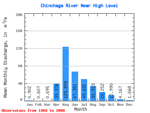
| Statistic | Jan | Feb | Mar | Apr | May | Jun | Jul | Aug | Sep | Oct | Nov | Dec | Annual |
|---|---|---|---|---|---|---|---|---|---|---|---|---|---|
| Mean | 0.90 | 0.61 | 0.69 | 39.38 | 123.90 | 67.38 | 49.63 | 33.91 | 20.25 | 12.99 | 4.17 | 1.67 | 29.59 |
| Standard Deviation | 0.65 | 0.49 | 1.25 | 37.99 | 93.36 | 60.78 | 43.13 | 44.64 | 21.67 | 16.60 | 4.53 | 1.17 | 14.97 |
| Min | 0.10 | 0.03 | 0.00 | 0.90 | 5.15 | 10.30 | 2.04 | 3.29 | 1.00 | 1.16 | 0.65 | 0.12 | 9.84 |
| Max | 2.33 | 1.93 | 7.10 | 172.00 | 406.00 | 304.00 | 169.00 | 201.00 | 101.00 | 90.00 | 26.00 | 4.99 | 81.47 |
| Coefficient of Variation | 0.72 | 0.82 | 1.81 | 0.96 | 0.75 | 0.90 | 0.87 | 1.32 | 1.07 | 1.28 | 1.09 | 0.70 | 0.51 |
 Return to R-Arctic Net Home Page