|
|
|||||||||||||||||
| Point ID: 814 | Downloads | Plots | Site Data | Code: 07OC001 |
|
|
|||||||||||||||||
| Download | |
|---|---|
| Site Descriptor Information | Site Time Series Data |
| Link to all available data | |
| View: | Time Series | All |
| Units: | m3/s |
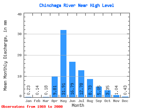
| Statistic | Jan | Feb | Mar | Apr | May | Jun | Jul | Aug | Sep | Oct | Nov | Dec | Annual |
|---|---|---|---|---|---|---|---|---|---|---|---|---|---|
| Mean | 0.23 | 0.14 | 0.18 | 9.81 | 31.90 | 16.79 | 12.78 | 8.73 | 5.05 | 3.34 | 1.04 | 0.43 | 89.80 |
| Standard Deviation | 0.17 | 0.12 | 0.32 | 9.47 | 24.04 | 15.15 | 11.11 | 11.49 | 5.40 | 4.28 | 1.13 | 0.30 | 45.43 |
| Min | 0.02 | 0.01 | 0.00 | 0.22 | 1.33 | 2.57 | 0.53 | 0.85 | 0.25 | 0.30 | 0.16 | 0.03 | 29.87 |
| Max | 0.60 | 0.45 | 1.83 | 42.87 | 104.55 | 75.77 | 43.52 | 51.76 | 25.17 | 23.18 | 6.48 | 1.28 | 247.22 |
| Coefficient of Variation | 0.72 | 0.82 | 1.81 | 0.96 | 0.75 | 0.90 | 0.87 | 1.32 | 1.07 | 1.28 | 1.09 | 0.70 | 0.51 |
 Return to R-Arctic Net Home Page