|
|
|||||||||||||||||
| Point ID: 8131 | Downloads | Plots | Site Data | Code: 1621 |
|
|
|||||||||||||||||
| Download | |
|---|---|
| Site Descriptor Information | Site Time Series Data |
| Link to all available data | |
| View: | Time Series | All |
| Units: | mm |
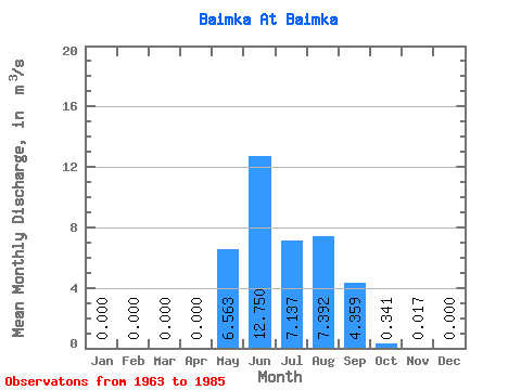
| Statistic | Jan | Feb | Mar | Apr | May | Jun | Jul | Aug | Sep | Oct | Nov | Dec | Annual |
|---|---|---|---|---|---|---|---|---|---|---|---|---|---|
| Mean | 0.00 | 0.00 | 0.00 | 0.00 | 6.56 | 12.75 | 7.14 | 7.39 | 4.36 | 0.34 | 0.02 | 0.00 | 3.21 |
| Standard Deviation | 0.00 | 0.00 | 0.00 | 0.00 | 4.26 | 6.76 | 4.52 | 4.70 | 3.19 | 0.21 | 0.02 | 0.00 | 0.86 |
| Min | 0.00 | 0.00 | 0.00 | 0.00 | 0.07 | 4.59 | 1.01 | 2.01 | 1.71 | 0.07 | 0.00 | 0.00 | 1.07 |
| Max | 0.00 | 0.00 | 0.00 | 0.00 | 15.00 | 31.00 | 20.20 | 19.60 | 16.10 | 0.88 | 0.09 | 0.00 | 4.69 |
| Coefficient of Variation | 0.65 | 0.53 | 0.63 | 0.64 | 0.73 | 0.63 | 1.42 | 0.27 |
 Return to R-Arctic Net Home Page