|
|
|||||||||||||||||
| Point ID: 8131 | Downloads | Plots | Site Data | Code: 1621 |
|
|
|||||||||||||||||
| Download | |
|---|---|
| Site Descriptor Information | Site Time Series Data |
| Link to all available data | |
| View: | Time Series | All |
| Units: | m3/s |
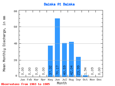
| Statistic | Jan | Feb | Mar | Apr | May | Jun | Jul | Aug | Sep | Oct | Nov | Dec | Annual |
|---|---|---|---|---|---|---|---|---|---|---|---|---|---|
| Mean | 0.00 | 0.00 | 0.00 | 0.00 | 37.32 | 70.17 | 40.58 | 42.03 | 23.99 | 1.94 | 0.09 | 0.00 | 215.30 |
| Standard Deviation | 0.00 | 0.00 | 0.00 | 0.00 | 24.24 | 37.22 | 25.72 | 26.70 | 17.58 | 1.22 | 0.13 | 0.00 | 57.93 |
| Min | 0.00 | 0.00 | 0.00 | 0.00 | 0.37 | 25.26 | 5.74 | 11.43 | 9.41 | 0.37 | 0.00 | 0.00 | 72.00 |
| Max | 0.00 | 0.00 | 0.00 | 0.00 | 85.29 | 170.60 | 114.85 | 111.44 | 88.60 | 5.01 | 0.49 | 0.00 | 314.55 |
| Coefficient of Variation | 0.65 | 0.53 | 0.63 | 0.64 | 0.73 | 0.63 | 1.42 | 0.27 |
 Return to R-Arctic Net Home Page