|
|
|||||||||||||||||
| Point ID: 8122 | Downloads | Plots | Site Data | Code: 1604 |
|
|
|||||||||||||||||
| Download | |
|---|---|
| Site Descriptor Information | Site Time Series Data |
| Link to all available data | |
| View: | Time Series | All |
| Units: | mm |
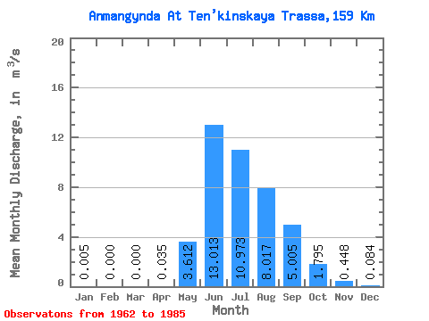
| Statistic | Jan | Feb | Mar | Apr | May | Jun | Jul | Aug | Sep | Oct | Nov | Dec | Annual |
|---|---|---|---|---|---|---|---|---|---|---|---|---|---|
| Mean | 0.01 | 0.00 | 0.00 | 0.04 | 3.61 | 13.01 | 10.97 | 8.02 | 5.00 | 1.79 | 0.45 | 0.08 | 3.58 |
| Standard Deviation | 0.01 | 0.00 | 0.00 | 0.06 | 2.78 | 6.24 | 5.22 | 2.89 | 2.22 | 0.59 | 0.24 | 0.11 | 0.91 |
| Min | 0.00 | 0.00 | 0.00 | 0.00 | 0.41 | 5.61 | 4.76 | 3.89 | 2.58 | 0.55 | 0.06 | 0.00 | 2.10 |
| Max | 0.05 | 0.00 | 0.00 | 0.23 | 14.00 | 27.40 | 29.60 | 13.30 | 11.80 | 3.12 | 1.05 | 0.37 | 5.90 |
| Coefficient of Variation | 2.46 | 1.62 | 0.77 | 0.48 | 0.48 | 0.36 | 0.44 | 0.33 | 0.54 | 1.33 | 0.25 |
 Return to R-Arctic Net Home Page