|
|
|||||||||||||||||
| Point ID: 8122 | Downloads | Plots | Site Data | Code: 1604 |
|
|
|||||||||||||||||
| Download | |
|---|---|
| Site Descriptor Information | Site Time Series Data |
| Link to all available data | |
| View: | Time Series | All |
| Units: | m3/s |
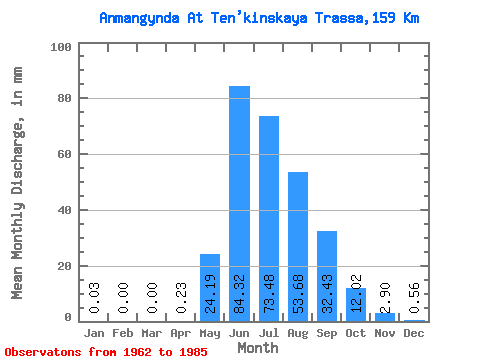
| Statistic | Jan | Feb | Mar | Apr | May | Jun | Jul | Aug | Sep | Oct | Nov | Dec | Annual |
|---|---|---|---|---|---|---|---|---|---|---|---|---|---|
| Mean | 0.03 | 0.00 | 0.00 | 0.23 | 24.18 | 84.32 | 73.46 | 53.67 | 32.43 | 12.02 | 2.91 | 0.56 | 282.63 |
| Standard Deviation | 0.08 | 0.00 | 0.00 | 0.36 | 18.62 | 40.42 | 34.95 | 19.33 | 14.41 | 3.95 | 1.55 | 0.75 | 71.65 |
| Min | 0.00 | 0.00 | 0.00 | 0.00 | 2.75 | 36.35 | 31.87 | 26.04 | 16.72 | 3.68 | 0.40 | 0.00 | 165.28 |
| Max | 0.35 | 0.00 | 0.00 | 1.49 | 93.73 | 177.55 | 198.17 | 89.04 | 76.47 | 20.89 | 6.80 | 2.48 | 465.51 |
| Coefficient of Variation | 2.46 | 1.62 | 0.77 | 0.48 | 0.48 | 0.36 | 0.44 | 0.33 | 0.54 | 1.33 | 0.25 |
 Return to R-Arctic Net Home Page