|
|
|||||||||||||||||
| Point ID: 8117 | Downloads | Plots | Site Data | Code: 1593 |
|
|
|||||||||||||||||
| Download | |
|---|---|
| Site Descriptor Information | Site Time Series Data |
| Link to all available data | |
| View: | Time Series | All |
| Units: | mm |
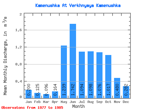
| Statistic | Jan | Feb | Mar | Apr | May | Jun | Jul | Aug | Sep | Oct | Nov | Dec | Annual |
|---|---|---|---|---|---|---|---|---|---|---|---|---|---|
| Mean | 0.20 | 0.12 | 0.10 | 0.16 | 1.24 | 1.74 | 1.09 | 1.10 | 1.08 | 1.02 | 0.48 | 0.28 | 0.74 |
| Standard Deviation | 0.07 | 0.06 | 0.03 | 0.14 | 0.41 | 1.48 | 0.84 | 0.41 | 0.28 | 0.42 | 0.12 | 0.08 | 0.21 |
| Min | 0.09 | 0.05 | 0.04 | 0.09 | 0.88 | 0.54 | 0.40 | 0.48 | 0.68 | 0.58 | 0.35 | 0.15 | 0.40 |
| Max | 0.29 | 0.19 | 0.13 | 0.54 | 1.92 | 4.47 | 2.77 | 1.71 | 1.60 | 1.95 | 0.70 | 0.39 | 1.05 |
| Coefficient of Variation | 0.33 | 0.46 | 0.34 | 0.88 | 0.33 | 0.85 | 0.77 | 0.37 | 0.27 | 0.41 | 0.24 | 0.28 | 0.29 |
 Return to R-Arctic Net Home Page