|
|
|||||||||||||||||
| Point ID: 8117 | Downloads | Plots | Site Data | Code: 1593 |
|
|
|||||||||||||||||
| Download | |
|---|---|
| Site Descriptor Information | Site Time Series Data |
| Link to all available data | |
| View: | Time Series | All |
| Units: | m3/s |
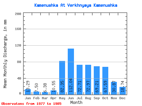
| Statistic | Jan | Feb | Mar | Apr | May | Jun | Jul | Aug | Sep | Oct | Nov | Dec | Annual |
|---|---|---|---|---|---|---|---|---|---|---|---|---|---|
| Mean | 13.30 | 7.56 | 6.35 | 10.52 | 82.34 | 112.06 | 72.73 | 72.95 | 69.18 | 67.56 | 30.87 | 18.75 | 577.65 |
| Standard Deviation | 4.41 | 3.45 | 2.16 | 9.27 | 27.29 | 95.35 | 55.68 | 27.31 | 18.30 | 27.68 | 7.54 | 5.22 | 166.29 |
| Min | 6.05 | 2.79 | 2.73 | 5.66 | 58.48 | 34.73 | 26.58 | 31.90 | 43.74 | 38.54 | 22.51 | 9.97 | 316.51 |
| Max | 19.27 | 11.50 | 8.64 | 34.77 | 127.63 | 287.50 | 184.07 | 113.63 | 102.91 | 129.58 | 45.02 | 25.92 | 818.89 |
| Coefficient of Variation | 0.33 | 0.46 | 0.34 | 0.88 | 0.33 | 0.85 | 0.77 | 0.37 | 0.27 | 0.41 | 0.24 | 0.28 | 0.29 |
 Return to R-Arctic Net Home Page