|
|
|||||||||||||||||
| Point ID: 8112 | Downloads | Plots | Site Data | Code: 1580 |
|
|
|||||||||||||||||
| Download | |
|---|---|
| Site Descriptor Information | Site Time Series Data |
| Link to all available data | |
| View: | Time Series | All |
| Units: | mm |
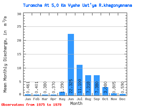
| Statistic | Jan | Feb | Mar | Apr | May | Jun | Jul | Aug | Sep | Oct | Nov | Dec | Annual |
|---|---|---|---|---|---|---|---|---|---|---|---|---|---|
| Mean | 0.46 | 0.40 | 0.38 | 0.37 | 1.39 | 22.32 | 11.10 | 7.32 | 7.38 | 3.08 | 0.81 | 0.59 | |
| Standard Deviation | 0.22 | 8.44 | 4.71 | 2.71 | 3.65 | 1.53 | 0.13 | 0.00 | |||||
| Min | 0.46 | 0.40 | 0.38 | 0.37 | 1.20 | 13.00 | 6.49 | 4.00 | 4.01 | 1.72 | 0.71 | 0.59 | |
| Max | 0.46 | 0.40 | 0.38 | 0.37 | 1.63 | 33.50 | 15.50 | 10.90 | 12.10 | 4.73 | 0.90 | 0.59 | |
| Coefficient of Variation | 0.16 | 0.38 | 0.42 | 0.37 | 0.49 | 0.49 | 0.17 | 0.00 |
 Return to R-Arctic Net Home Page