|
|
|||||||||||||||||
| Point ID: 8112 | Downloads | Plots | Site Data | Code: 1580 |
|
|
|||||||||||||||||
| Download | |
|---|---|
| Site Descriptor Information | Site Time Series Data |
| Link to all available data | |
| View: | Time Series | All |
| Units: | m3/s |
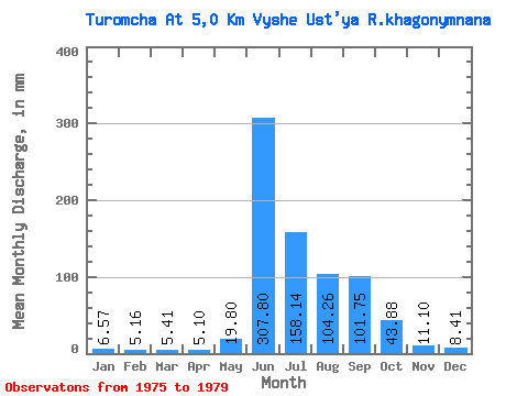
| Statistic | Jan | Feb | Mar | Apr | May | Jun | Jul | Aug | Sep | Oct | Nov | Dec | Annual |
|---|---|---|---|---|---|---|---|---|---|---|---|---|---|
| Mean | 6.56 | 5.20 | 5.41 | 5.10 | 19.80 | 307.80 | 158.12 | 104.24 | 101.75 | 43.88 | 11.10 | 8.41 | |
| Standard Deviation | 3.12 | 116.41 | 67.06 | 38.60 | 50.25 | 21.73 | 1.85 | 0.01 | |||||
| Min | 6.56 | 5.20 | 5.41 | 5.10 | 17.09 | 179.23 | 92.45 | 56.98 | 55.29 | 24.51 | 9.80 | 8.40 | |
| Max | 6.56 | 5.20 | 5.41 | 5.10 | 23.22 | 461.87 | 220.79 | 155.27 | 166.83 | 67.38 | 12.41 | 8.41 | |
| Coefficient of Variation | 0.16 | 0.38 | 0.42 | 0.37 | 0.49 | 0.49 | 0.17 | 0.00 |
 Return to R-Arctic Net Home Page