|
|
|||||||||||||||||
| Point ID: 8106 | Downloads | Plots | Site Data | Code: 1565 |
|
|
|||||||||||||||||
| Download | |
|---|---|
| Site Descriptor Information | Site Time Series Data |
| Link to all available data | |
| View: | Time Series | All |
| Units: | mm |
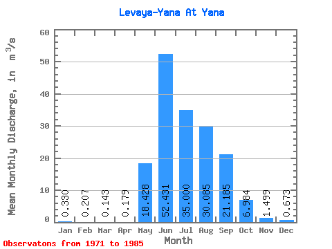
| Statistic | Jan | Feb | Mar | Apr | May | Jun | Jul | Aug | Sep | Oct | Nov | Dec | Annual |
|---|---|---|---|---|---|---|---|---|---|---|---|---|---|
| Mean | 0.33 | 0.21 | 0.14 | 0.18 | 18.43 | 52.43 | 35.00 | 30.09 | 21.18 | 6.98 | 1.50 | 0.67 | 14.34 |
| Standard Deviation | 0.19 | 0.13 | 0.10 | 0.10 | 8.87 | 33.78 | 25.79 | 18.98 | 11.61 | 5.24 | 0.67 | 0.46 | 3.93 |
| Min | 0.00 | 0.00 | 0.00 | 0.01 | 6.48 | 10.90 | 13.30 | 10.80 | 5.66 | 2.59 | 0.64 | 0.13 | 8.82 |
| Max | 0.64 | 0.54 | 0.31 | 0.36 | 40.10 | 113.00 | 110.00 | 69.30 | 45.80 | 18.10 | 2.61 | 1.48 | 22.23 |
| Coefficient of Variation | 0.57 | 0.64 | 0.67 | 0.58 | 0.48 | 0.64 | 0.74 | 0.63 | 0.55 | 0.75 | 0.45 | 0.69 | 0.27 |
 Return to R-Arctic Net Home Page