|
|
|||||||||||||||||
| Point ID: 8106 | Downloads | Plots | Site Data | Code: 1565 |
|
|
|||||||||||||||||
| Download | |
|---|---|
| Site Descriptor Information | Site Time Series Data |
| Link to all available data | |
| View: | Time Series | All |
| Units: | m3/s |
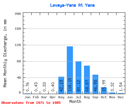
| Statistic | Jan | Feb | Mar | Apr | May | Jun | Jul | Aug | Sep | Oct | Nov | Dec | Annual |
|---|---|---|---|---|---|---|---|---|---|---|---|---|---|
| Mean | 0.76 | 0.43 | 0.33 | 0.40 | 42.18 | 116.15 | 80.11 | 68.86 | 46.93 | 15.98 | 3.32 | 1.54 | 386.87 |
| Standard Deviation | 0.43 | 0.28 | 0.22 | 0.23 | 20.30 | 74.85 | 59.03 | 43.44 | 25.72 | 12.00 | 1.49 | 1.06 | 105.95 |
| Min | 0.00 | 0.00 | 0.00 | 0.02 | 14.83 | 24.15 | 30.44 | 24.72 | 12.54 | 5.93 | 1.42 | 0.30 | 238.03 |
| Max | 1.47 | 1.13 | 0.71 | 0.80 | 91.78 | 250.34 | 251.78 | 158.62 | 101.47 | 41.43 | 5.78 | 3.39 | 599.55 |
| Coefficient of Variation | 0.57 | 0.64 | 0.67 | 0.58 | 0.48 | 0.64 | 0.74 | 0.63 | 0.55 | 0.75 | 0.45 | 0.69 | 0.27 |
 Return to R-Arctic Net Home Page