|
|
|||||||||||||||||
| Point ID: 8103 | Downloads | Plots | Site Data | Code: 1559 |
|
|
|||||||||||||||||
| Download | |
|---|---|
| Site Descriptor Information | Site Time Series Data |
| Link to all available data | |
| View: | Time Series | All |
| Units: | mm |
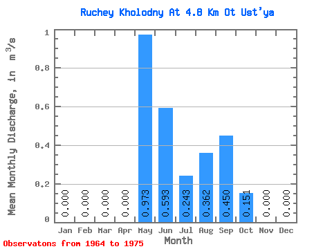
| Statistic | Jan | Feb | Mar | Apr | May | Jun | Jul | Aug | Sep | Oct | Nov | Dec | Annual |
|---|---|---|---|---|---|---|---|---|---|---|---|---|---|
| Mean | 0.00 | 0.00 | 0.00 | 0.00 | 0.97 | 0.59 | 0.24 | 0.36 | 0.45 | 0.15 | 0.00 | 0.00 | 0.23 |
| Standard Deviation | 0.00 | 0.00 | 0.00 | 0.00 | 0.63 | 0.38 | 0.23 | 0.43 | 0.36 | 0.27 | 0.00 | 0.00 | 0.09 |
| Min | 0.00 | 0.00 | 0.00 | 0.00 | 0.22 | 0.19 | 0.03 | 0.00 | 0.01 | 0.00 | 0.00 | 0.00 | 0.11 |
| Max | 0.00 | 0.00 | 0.00 | 0.00 | 2.48 | 1.51 | 0.80 | 1.55 | 1.35 | 0.86 | 0.00 | 0.00 | 0.35 |
| Coefficient of Variation | 0.64 | 0.64 | 0.95 | 1.20 | 0.81 | 1.79 | 0.37 |
 Return to R-Arctic Net Home Page