|
|
|||||||||||||||||
| Point ID: 8103 | Downloads | Plots | Site Data | Code: 1559 |
|
|
|||||||||||||||||
| Download | |
|---|---|
| Site Descriptor Information | Site Time Series Data |
| Link to all available data | |
| View: | Time Series | All |
| Units: | m3/s |
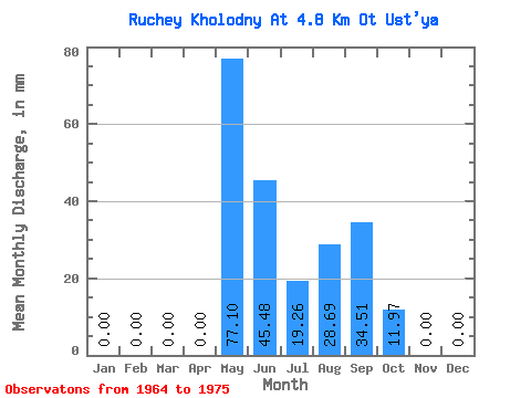
| Statistic | Jan | Feb | Mar | Apr | May | Jun | Jul | Aug | Sep | Oct | Nov | Dec | Annual |
|---|---|---|---|---|---|---|---|---|---|---|---|---|---|
| Mean | 0.00 | 0.00 | 0.00 | 0.00 | 77.07 | 45.44 | 19.27 | 28.72 | 34.48 | 11.94 | 0.00 | 0.00 | 217.60 |
| Standard Deviation | 0.00 | 0.00 | 0.00 | 0.00 | 49.59 | 29.13 | 18.22 | 34.49 | 27.88 | 21.34 | 0.00 | 0.00 | 79.62 |
| Min | 0.00 | 0.00 | 0.00 | 0.00 | 17.43 | 14.57 | 2.54 | 0.00 | 0.46 | 0.00 | 0.00 | 0.00 | 100.61 |
| Max | 0.00 | 0.00 | 0.00 | 0.00 | 196.49 | 115.80 | 63.38 | 122.81 | 103.53 | 68.14 | 0.00 | 0.00 | 330.66 |
| Coefficient of Variation | 0.64 | 0.64 | 0.95 | 1.20 | 0.81 | 1.79 | 0.37 |
 Return to R-Arctic Net Home Page