|
|
|||||||||||||||||
| Point ID: 8098 | Downloads | Plots | Site Data | Code: 1542 |
|
|
|||||||||||||||||
| Download | |
|---|---|
| Site Descriptor Information | Site Time Series Data |
| Link to all available data | |
| View: | Time Series | All |
| Units: | mm |
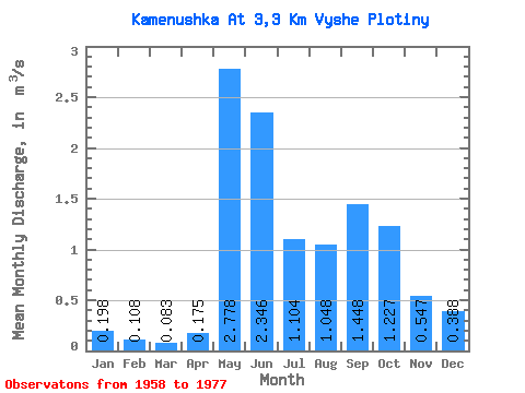
| Statistic | Jan | Feb | Mar | Apr | May | Jun | Jul | Aug | Sep | Oct | Nov | Dec | Annual |
|---|---|---|---|---|---|---|---|---|---|---|---|---|---|
| Mean | 0.20 | 0.11 | 0.08 | 0.17 | 2.78 | 2.35 | 1.10 | 1.05 | 1.45 | 1.23 | 0.55 | 0.39 | 0.96 |
| Standard Deviation | 0.08 | 0.07 | 0.06 | 0.10 | 1.20 | 0.75 | 0.41 | 0.40 | 0.61 | 0.53 | 0.18 | 0.14 | 0.22 |
| Min | 0.06 | 0.00 | 0.00 | 0.06 | 1.44 | 1.36 | 0.42 | 0.59 | 0.43 | 0.36 | 0.20 | 0.19 | 0.59 |
| Max | 0.42 | 0.32 | 0.26 | 0.51 | 5.52 | 3.89 | 1.80 | 1.93 | 3.15 | 2.65 | 0.85 | 0.59 | 1.42 |
| Coefficient of Variation | 0.42 | 0.68 | 0.75 | 0.58 | 0.43 | 0.32 | 0.38 | 0.38 | 0.42 | 0.43 | 0.34 | 0.35 | 0.23 |
 Return to R-Arctic Net Home Page