|
|
|||||||||||||||||
| Point ID: 8098 | Downloads | Plots | Site Data | Code: 1542 |
|
|
|||||||||||||||||
| Download | |
|---|---|
| Site Descriptor Information | Site Time Series Data |
| Link to all available data | |
| View: | Time Series | All |
| Units: | m3/s |
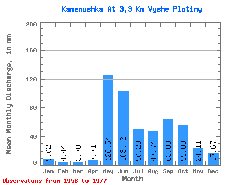
| Statistic | Jan | Feb | Mar | Apr | May | Jun | Jul | Aug | Sep | Oct | Nov | Dec | Annual |
|---|---|---|---|---|---|---|---|---|---|---|---|---|---|
| Mean | 9.01 | 4.49 | 3.78 | 7.73 | 126.50 | 103.41 | 50.29 | 47.73 | 63.83 | 55.90 | 24.11 | 17.69 | 512.91 |
| Standard Deviation | 3.79 | 3.06 | 2.84 | 4.50 | 54.67 | 33.24 | 18.91 | 18.14 | 27.08 | 23.99 | 8.10 | 6.15 | 116.71 |
| Min | 2.82 | 0.17 | 0.00 | 2.50 | 65.61 | 59.95 | 19.13 | 26.87 | 18.95 | 16.40 | 8.82 | 8.65 | 315.47 |
| Max | 19.13 | 13.28 | 11.84 | 22.48 | 251.40 | 171.48 | 81.98 | 87.90 | 138.86 | 120.69 | 37.47 | 26.87 | 763.50 |
| Coefficient of Variation | 0.42 | 0.68 | 0.75 | 0.58 | 0.43 | 0.32 | 0.38 | 0.38 | 0.42 | 0.43 | 0.34 | 0.35 | 0.23 |
 Return to R-Arctic Net Home Page