|
|
|||||||||||||||||
| Point ID: 8096 | Downloads | Plots | Site Data | Code: 1539 |
|
|
|||||||||||||||||
| Download | |
|---|---|
| Site Descriptor Information | Site Time Series Data |
| Link to all available data | |
| View: | Time Series | All |
| Units: | mm |
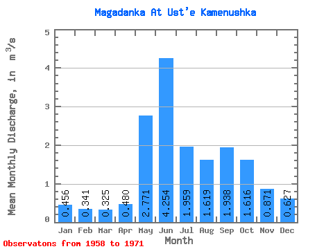
| Statistic | Jan | Feb | Mar | Apr | May | Jun | Jul | Aug | Sep | Oct | Nov | Dec | Annual |
|---|---|---|---|---|---|---|---|---|---|---|---|---|---|
| Mean | 0.46 | 0.34 | 0.33 | 0.48 | 2.77 | 4.25 | 1.96 | 1.62 | 1.94 | 1.62 | 0.87 | 0.63 | 1.44 |
| Standard Deviation | 0.14 | 0.11 | 0.12 | 0.14 | 1.14 | 1.61 | 0.80 | 0.51 | 0.68 | 0.52 | 0.22 | 0.17 | 0.30 |
| Min | 0.25 | 0.18 | 0.17 | 0.36 | 1.44 | 2.55 | 0.76 | 1.01 | 0.95 | 0.72 | 0.56 | 0.33 | 0.98 |
| Max | 0.67 | 0.54 | 0.58 | 0.93 | 5.18 | 8.07 | 3.48 | 2.86 | 3.17 | 2.74 | 1.38 | 0.88 | 1.91 |
| Coefficient of Variation | 0.31 | 0.33 | 0.37 | 0.28 | 0.41 | 0.38 | 0.41 | 0.31 | 0.35 | 0.32 | 0.26 | 0.27 | 0.21 |
 Return to R-Arctic Net Home Page