|
|
|||||||||||||||||
| Point ID: 8096 | Downloads | Plots | Site Data | Code: 1539 |
|
|
|||||||||||||||||
| Download | |
|---|---|
| Site Descriptor Information | Site Time Series Data |
| Link to all available data | |
| View: | Time Series | All |
| Units: | m3/s |
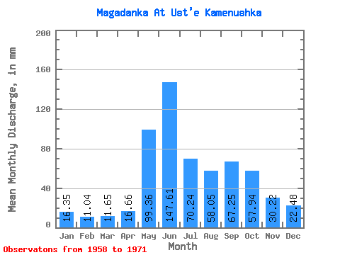
| Statistic | Jan | Feb | Mar | Apr | May | Jun | Jul | Aug | Sep | Oct | Nov | Dec | Annual |
|---|---|---|---|---|---|---|---|---|---|---|---|---|---|
| Mean | 16.34 | 11.13 | 11.65 | 16.66 | 99.36 | 147.59 | 70.24 | 58.05 | 67.24 | 57.92 | 30.21 | 22.48 | 607.56 |
| Standard Deviation | 5.12 | 3.69 | 4.28 | 4.75 | 41.00 | 55.73 | 28.84 | 18.14 | 23.69 | 18.53 | 7.78 | 6.15 | 125.51 |
| Min | 8.96 | 5.88 | 6.09 | 12.49 | 51.62 | 88.48 | 27.25 | 36.21 | 32.96 | 25.81 | 19.43 | 11.83 | 415.10 |
| Max | 24.02 | 17.64 | 20.79 | 32.27 | 185.70 | 280.02 | 124.76 | 102.53 | 110.00 | 98.23 | 47.88 | 31.55 | 806.60 |
| Coefficient of Variation | 0.31 | 0.33 | 0.37 | 0.28 | 0.41 | 0.38 | 0.41 | 0.31 | 0.35 | 0.32 | 0.26 | 0.27 | 0.21 |
 Return to R-Arctic Net Home Page