|
|
|||||||||||||||||
| Point ID: 8074 | Downloads | Plots | Site Data | Code: 1420 |
|
|
|||||||||||||||||
| Download | |
|---|---|
| Site Descriptor Information | Site Time Series Data |
| Link to all available data | |
| View: | Time Series | All |
| Units: | mm |
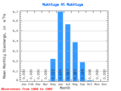
| Statistic | Jan | Feb | Mar | Apr | May | Jun | Jul | Aug | Sep | Oct | Nov | Dec | Annual |
|---|---|---|---|---|---|---|---|---|---|---|---|---|---|
| Mean | 0.00 | 0.00 | 0.00 | 0.00 | 0.22 | 0.69 | 0.57 | 0.39 | 0.19 | 0.01 | 0.00 | 0.00 | 0.17 |
| Standard Deviation | 0.00 | 0.00 | 0.00 | 0.00 | 0.25 | 0.33 | 0.45 | 0.25 | 0.17 | 0.01 | 0.00 | 0.00 | 0.07 |
| Min | 0.00 | 0.00 | 0.00 | 0.00 | 0.00 | 0.19 | 0.15 | 0.11 | 0.02 | 0.00 | 0.00 | 0.00 | 0.08 |
| Max | 0.00 | 0.00 | 0.00 | 0.00 | 1.07 | 1.42 | 2.42 | 1.32 | 0.82 | 0.04 | 0.00 | 0.00 | 0.46 |
| Coefficient of Variation | 1.11 | 0.48 | 0.80 | 0.65 | 0.91 | 1.22 | 0.42 |
 Return to R-Arctic Net Home Page