|
|
|||||||||||||||||
| Point ID: 8074 | Downloads | Plots | Site Data | Code: 1420 |
|
|
|||||||||||||||||
| Download | |
|---|---|
| Site Descriptor Information | Site Time Series Data |
| Link to all available data | |
| View: | Time Series | All |
| Units: | m3/s |
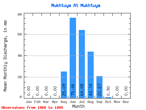
| Statistic | Jan | Feb | Mar | Apr | May | Jun | Jul | Aug | Sep | Oct | Nov | Dec | Annual |
|---|---|---|---|---|---|---|---|---|---|---|---|---|---|
| Mean | 0.00 | 0.00 | 0.00 | 0.00 | 25.05 | 75.43 | 64.11 | 43.68 | 20.67 | 0.89 | 0.00 | 0.00 | 228.84 |
| Standard Deviation | 0.00 | 0.00 | 0.00 | 0.00 | 27.89 | 36.02 | 50.96 | 28.27 | 18.85 | 1.08 | 0.00 | 0.00 | 97.27 |
| Min | 0.00 | 0.00 | 0.00 | 0.00 | 0.00 | 20.78 | 16.95 | 12.43 | 2.19 | 0.00 | 0.00 | 0.00 | 108.64 |
| Max | 0.00 | 0.00 | 0.00 | 0.00 | 120.91 | 155.30 | 273.45 | 149.17 | 89.69 | 4.87 | 0.00 | 0.00 | 616.28 |
| Coefficient of Variation | 1.11 | 0.48 | 0.80 | 0.65 | 0.91 | 1.22 | 0.42 |
 Return to R-Arctic Net Home Page