|
|
|||||||||||||||||
| Point ID: 807 | Downloads | Plots | Site Data | Code: 07NB008 |
|
|
|||||||||||||||||
| Download | |
|---|---|
| Site Descriptor Information | Site Time Series Data |
| Link to all available data | |
| View: | Time Series | All |
| Units: | mm |
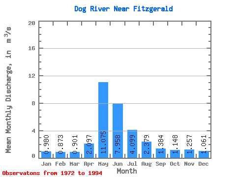
| Statistic | Jan | Feb | Mar | Apr | May | Jun | Jul | Aug | Sep | Oct | Nov | Dec | Annual |
|---|---|---|---|---|---|---|---|---|---|---|---|---|---|
| Mean | 0.98 | 0.87 | 0.90 | 2.10 | 11.07 | 7.96 | 4.10 | 2.38 | 1.38 | 1.15 | 1.26 | 1.06 | 2.69 |
| Standard Deviation | 0.84 | 0.66 | 0.60 | 1.48 | 9.90 | 5.89 | 2.91 | 1.93 | 1.36 | 1.16 | 1.52 | 1.33 | 1.71 |
| Min | 0.01 | 0.01 | 0.01 | 0.27 | 0.66 | 0.12 | 0.01 | 0.00 | 0.00 | 0.06 | 0.07 | 0.02 | 0.17 |
| Max | 3.64 | 2.60 | 2.12 | 6.15 | 32.60 | 19.10 | 9.39 | 7.95 | 5.74 | 4.75 | 7.19 | 6.47 | 5.53 |
| Coefficient of Variation | 0.86 | 0.75 | 0.66 | 0.70 | 0.89 | 0.74 | 0.71 | 0.81 | 0.98 | 1.01 | 1.21 | 1.25 | 0.64 |
 Return to R-Arctic Net Home Page