|
|
|||||||||||||||||
| Point ID: 807 | Downloads | Plots | Site Data | Code: 07NB008 |
|
|
|||||||||||||||||
| Download | |
|---|---|
| Site Descriptor Information | Site Time Series Data |
| Link to all available data | |
| View: | Time Series | All |
| Units: | m3/s |
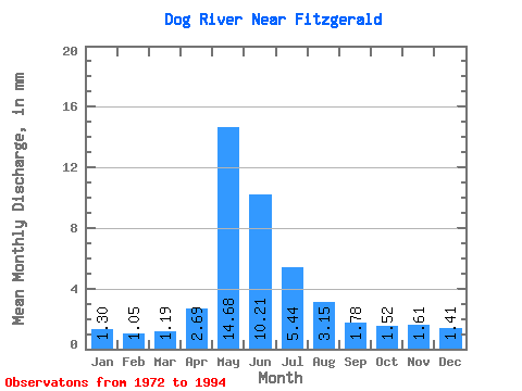
| Statistic | Jan | Feb | Mar | Apr | May | Jun | Jul | Aug | Sep | Oct | Nov | Dec | Annual |
|---|---|---|---|---|---|---|---|---|---|---|---|---|---|
| Mean | 1.30 | 1.05 | 1.19 | 2.69 | 14.68 | 10.21 | 5.43 | 3.15 | 1.78 | 1.52 | 1.61 | 1.41 | 42.09 |
| Standard Deviation | 1.12 | 0.79 | 0.79 | 1.89 | 13.13 | 7.55 | 3.86 | 2.56 | 1.74 | 1.54 | 1.96 | 1.76 | 26.73 |
| Min | 0.01 | 0.01 | 0.01 | 0.35 | 0.88 | 0.15 | 0.01 | 0.00 | 0.01 | 0.08 | 0.09 | 0.02 | 2.73 |
| Max | 4.83 | 3.14 | 2.81 | 7.89 | 43.22 | 24.51 | 12.45 | 10.54 | 7.37 | 6.30 | 9.23 | 8.58 | 86.40 |
| Coefficient of Variation | 0.86 | 0.75 | 0.66 | 0.70 | 0.89 | 0.74 | 0.71 | 0.81 | 0.98 | 1.01 | 1.21 | 1.25 | 0.64 |
 Return to R-Arctic Net Home Page