|
|
|||||||||||||||||
| Point ID: 8069 | Downloads | Plots | Site Data | Code: 1400 |
|
|
|||||||||||||||||
| Download | |
|---|---|
| Site Descriptor Information | Site Time Series Data |
| Link to all available data | |
| View: | Time Series | All |
| Units: | mm |
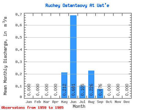
| Statistic | Jan | Feb | Mar | Apr | May | Jun | Jul | Aug | Sep | Oct | Nov | Dec | Annual |
|---|---|---|---|---|---|---|---|---|---|---|---|---|---|
| Mean | 0.00 | 0.00 | 0.00 | 0.00 | 0.21 | 0.68 | 0.10 | 0.23 | 0.08 | 0.00 | 0.00 | 0.00 | 0.11 |
| Standard Deviation | 0.00 | 0.00 | 0.00 | 0.00 | 0.19 | 0.32 | 0.15 | 0.17 | 0.09 | 0.00 | 0.00 | 0.00 | 0.03 |
| Min | 0.00 | 0.00 | 0.00 | 0.00 | 0.00 | 0.14 | 0.01 | 0.01 | 0.01 | 0.00 | 0.00 | 0.00 | 0.07 |
| Max | 0.00 | 0.00 | 0.00 | 0.00 | 0.62 | 1.33 | 0.65 | 0.54 | 0.36 | 0.00 | 0.00 | 0.00 | 0.18 |
| Coefficient of Variation | 0.89 | 0.46 | 1.43 | 0.73 | 1.21 | 2.29 | 0.24 |
 Return to R-Arctic Net Home Page