|
|
|||||||||||||||||
| Point ID: 8069 | Downloads | Plots | Site Data | Code: 1400 |
|
|
|||||||||||||||||
| Download | |
|---|---|
| Site Descriptor Information | Site Time Series Data |
| Link to all available data | |
| View: | Time Series | All |
| Units: | m3/s |
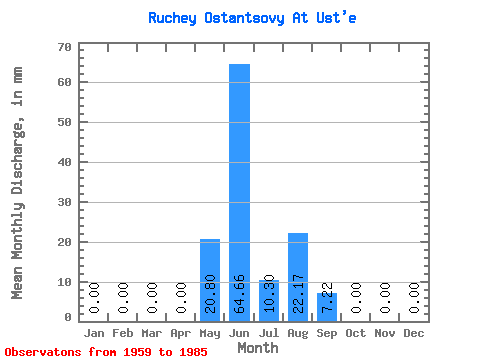
| Statistic | Jan | Feb | Mar | Apr | May | Jun | Jul | Aug | Sep | Oct | Nov | Dec | Annual |
|---|---|---|---|---|---|---|---|---|---|---|---|---|---|
| Mean | 0.00 | 0.00 | 0.00 | 0.00 | 20.79 | 64.69 | 10.27 | 22.19 | 7.25 | 0.03 | 0.00 | 0.00 | 122.39 |
| Standard Deviation | 0.00 | 0.00 | 0.00 | 0.00 | 18.39 | 30.03 | 14.71 | 16.25 | 8.77 | 0.06 | 0.00 | 0.00 | 29.11 |
| Min | 0.00 | 0.00 | 0.00 | 0.00 | 0.00 | 13.29 | 1.18 | 0.88 | 0.91 | 0.00 | 0.00 | 0.00 | 82.29 |
| Max | 0.00 | 0.00 | 0.00 | 0.00 | 60.82 | 126.28 | 63.76 | 52.97 | 34.18 | 0.20 | 0.00 | 0.00 | 208.38 |
| Coefficient of Variation | 0.89 | 0.46 | 1.43 | 0.73 | 1.21 | 2.29 | 0.24 |
 Return to R-Arctic Net Home Page