|
|
|||||||||||||||||
| Point ID: 8055 | Downloads | Plots | Site Data | Code: 1192 |
|
|
|||||||||||||||||
| Download | |
|---|---|
| Site Descriptor Information | Site Time Series Data |
| Link to all available data | |
| View: | Time Series | All |
| Units: | mm |
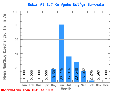
| Statistic | Jan | Feb | Mar | Apr | May | Jun | Jul | Aug | Sep | Oct | Nov | Dec | Annual |
|---|---|---|---|---|---|---|---|---|---|---|---|---|---|
| Mean | 0.00 | 0.00 | 0.00 | 0.00 | 18.59 | 80.78 | 35.92 | 28.55 | 16.03 | 2.21 | 0.09 | 0.00 | 15.18 |
| Standard Deviation | 0.00 | 0.00 | 0.00 | 0.00 | 13.91 | 33.49 | 13.31 | 11.21 | 7.61 | 1.84 | 0.25 | 0.00 | 2.73 |
| Min | 0.00 | 0.00 | 0.00 | 0.00 | 0.16 | 30.60 | 16.00 | 12.20 | 5.63 | 0.64 | 0.00 | 0.00 | 8.23 |
| Max | 0.00 | 0.00 | 0.00 | 0.00 | 50.60 | 152.00 | 63.80 | 51.20 | 30.50 | 9.76 | 1.25 | 0.00 | 19.45 |
| Coefficient of Variation | 0.75 | 0.41 | 0.37 | 0.39 | 0.47 | 0.83 | 2.76 | 5.00 | 0.18 |
 Return to R-Arctic Net Home Page