|
|
|||||||||||||||||
| Point ID: 8055 | Downloads | Plots | Site Data | Code: 1192 |
|
|
|||||||||||||||||
| Download | |
|---|---|
| Site Descriptor Information | Site Time Series Data |
| Link to all available data | |
| View: | Time Series | All |
| Units: | m3/s |
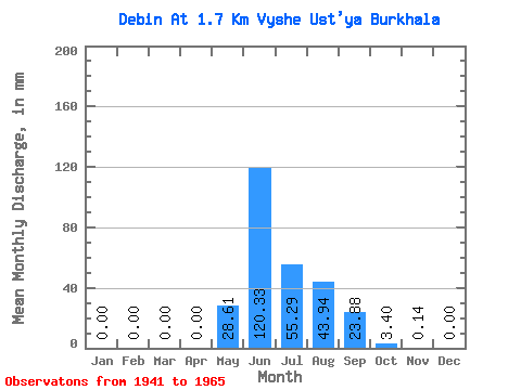
| Statistic | Jan | Feb | Mar | Apr | May | Jun | Jul | Aug | Sep | Oct | Nov | Dec | Annual |
|---|---|---|---|---|---|---|---|---|---|---|---|---|---|
| Mean | 0.00 | 0.00 | 0.00 | 0.00 | 28.61 | 120.33 | 55.28 | 43.94 | 23.88 | 3.40 | 0.14 | 0.00 | 275.33 |
| Standard Deviation | 0.00 | 0.00 | 0.00 | 0.00 | 21.41 | 49.88 | 20.48 | 17.25 | 11.34 | 2.83 | 0.38 | 0.00 | 49.45 |
| Min | 0.00 | 0.00 | 0.00 | 0.00 | 0.25 | 45.58 | 24.62 | 18.78 | 8.39 | 0.98 | 0.00 | 0.00 | 149.23 |
| Max | 0.00 | 0.00 | 0.00 | 0.00 | 77.88 | 226.43 | 98.19 | 78.80 | 45.43 | 15.02 | 1.86 | 0.01 | 352.83 |
| Coefficient of Variation | 0.75 | 0.41 | 0.37 | 0.39 | 0.47 | 0.83 | 2.76 | 5.00 | 0.18 |
 Return to R-Arctic Net Home Page