|
|
|||||||||||||||||
| Point ID: 8047 | Downloads | Plots | Site Data | Code: 1130 |
|
|
|||||||||||||||||
| Download | |
|---|---|
| Site Descriptor Information | Site Time Series Data |
| Link to all available data | |
| View: | Time Series | All |
| Units: | mm |
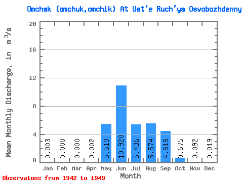
| Statistic | Jan | Feb | Mar | Apr | May | Jun | Jul | Aug | Sep | Oct | Nov | Dec | Annual |
|---|---|---|---|---|---|---|---|---|---|---|---|---|---|
| Mean | 0.00 | 0.00 | 0.00 | 0.00 | 5.52 | 10.92 | 5.44 | 5.57 | 4.51 | 0.68 | 0.09 | 0.02 | 2.73 |
| Standard Deviation | 0.01 | 0.00 | 0.00 | 0.01 | 4.12 | 6.04 | 2.07 | 2.83 | 3.64 | 0.67 | 0.08 | 0.02 | 0.83 |
| Min | 0.00 | 0.00 | 0.00 | 0.00 | 0.34 | 5.95 | 2.57 | 1.43 | 0.81 | 0.22 | 0.00 | 0.00 | 1.06 |
| Max | 0.01 | 0.00 | 0.00 | 0.02 | 11.80 | 23.20 | 8.57 | 8.58 | 10.30 | 2.21 | 0.21 | 0.06 | 3.81 |
| Coefficient of Variation | 1.98 | 2.83 | 0.75 | 0.55 | 0.38 | 0.51 | 0.81 | 0.99 | 0.90 | 1.17 | 0.30 |
 Return to R-Arctic Net Home Page