|
|
|||||||||||||||||
| Point ID: 8047 | Downloads | Plots | Site Data | Code: 1130 |
|
|
|||||||||||||||||
| Download | |
|---|---|
| Site Descriptor Information | Site Time Series Data |
| Link to all available data | |
| View: | Time Series | All |
| Units: | m3/s |
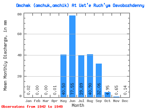
| Statistic | Jan | Feb | Mar | Apr | May | Jun | Jul | Aug | Sep | Oct | Nov | Dec | Annual |
|---|---|---|---|---|---|---|---|---|---|---|---|---|---|
| Mean | 0.02 | 0.00 | 0.00 | 0.02 | 40.49 | 77.55 | 39.89 | 40.90 | 32.06 | 4.95 | 0.65 | 0.14 | 236.01 |
| Standard Deviation | 0.04 | 0.00 | 0.00 | 0.04 | 30.26 | 42.92 | 15.19 | 20.77 | 25.85 | 4.89 | 0.59 | 0.16 | 71.95 |
| Min | 0.00 | 0.00 | 0.00 | 0.00 | 2.50 | 42.25 | 18.86 | 10.49 | 5.75 | 1.61 | 0.00 | 0.00 | 91.94 |
| Max | 0.10 | 0.00 | 0.00 | 0.13 | 86.58 | 164.75 | 62.88 | 62.95 | 73.14 | 16.21 | 1.49 | 0.41 | 329.74 |
| Coefficient of Variation | 1.98 | 2.83 | 0.75 | 0.55 | 0.38 | 0.51 | 0.81 | 0.99 | 0.90 | 1.17 | 0.30 |
 Return to R-Arctic Net Home Page