|
|
|||||||||||||||||
| Point ID: 8044 | Downloads | Plots | Site Data | Code: 1110 |
|
|
|||||||||||||||||
| Download | |
|---|---|
| Site Descriptor Information | Site Time Series Data |
| Link to all available data | |
| View: | Time Series | All |
| Units: | mm |
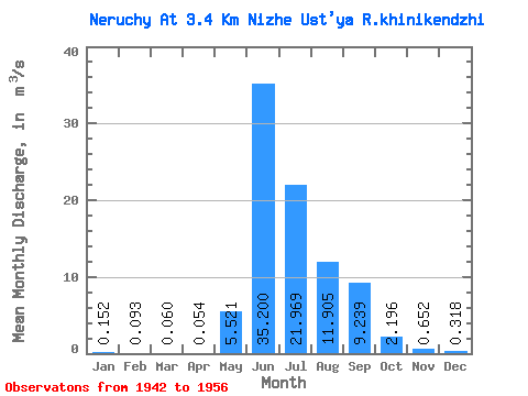
| Statistic | Jan | Feb | Mar | Apr | May | Jun | Jul | Aug | Sep | Oct | Nov | Dec | Annual |
|---|---|---|---|---|---|---|---|---|---|---|---|---|---|
| Mean | 0.15 | 0.09 | 0.06 | 0.05 | 5.52 | 35.20 | 21.97 | 11.90 | 9.24 | 2.20 | 0.65 | 0.32 | 7.18 |
| Standard Deviation | 0.09 | 0.07 | 0.06 | 0.07 | 6.99 | 17.81 | 13.03 | 4.46 | 6.39 | 1.08 | 0.24 | 0.12 | 1.97 |
| Min | 0.04 | 0.00 | 0.00 | 0.00 | 0.09 | 12.30 | 9.17 | 6.24 | 2.57 | 1.17 | 0.35 | 0.16 | 3.05 |
| Max | 0.42 | 0.28 | 0.23 | 0.28 | 20.30 | 69.90 | 53.80 | 20.40 | 24.60 | 4.68 | 1.17 | 0.54 | 9.87 |
| Coefficient of Variation | 0.62 | 0.77 | 0.95 | 1.28 | 1.27 | 0.51 | 0.59 | 0.37 | 0.69 | 0.49 | 0.37 | 0.39 | 0.28 |
 Return to R-Arctic Net Home Page