|
|
|||||||||||||||||
| Point ID: 8044 | Downloads | Plots | Site Data | Code: 1110 |
|
|
|||||||||||||||||
| Download | |
|---|---|
| Site Descriptor Information | Site Time Series Data |
| Link to all available data | |
| View: | Time Series | All |
| Units: | m3/s |
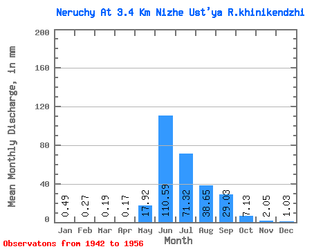
| Statistic | Jan | Feb | Mar | Apr | May | Jun | Jul | Aug | Sep | Oct | Nov | Dec | Annual |
|---|---|---|---|---|---|---|---|---|---|---|---|---|---|
| Mean | 0.49 | 0.28 | 0.19 | 0.17 | 17.92 | 110.59 | 71.31 | 38.64 | 29.03 | 7.13 | 2.05 | 1.03 | 274.83 |
| Standard Deviation | 0.30 | 0.21 | 0.18 | 0.22 | 22.69 | 55.95 | 42.29 | 14.46 | 20.09 | 3.52 | 0.76 | 0.40 | 75.47 |
| Min | 0.12 | 0.00 | 0.00 | 0.00 | 0.28 | 38.64 | 29.77 | 20.25 | 8.07 | 3.80 | 1.10 | 0.52 | 116.84 |
| Max | 1.36 | 0.83 | 0.75 | 0.88 | 65.89 | 219.61 | 174.64 | 66.22 | 77.29 | 15.19 | 3.68 | 1.75 | 377.64 |
| Coefficient of Variation | 0.62 | 0.77 | 0.95 | 1.28 | 1.27 | 0.51 | 0.59 | 0.37 | 0.69 | 0.49 | 0.37 | 0.39 | 0.28 |
 Return to R-Arctic Net Home Page