|
|
|||||||||||||||||
| Point ID: 8033 | Downloads | Plots | Site Data | Code: 1051 |
|
|
|||||||||||||||||
| Download | |
|---|---|
| Site Descriptor Information | Site Time Series Data |
| Link to all available data | |
| View: | Time Series | All |
| Units: | mm |
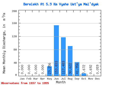
| Statistic | Jan | Feb | Mar | Apr | May | Jun | Jul | Aug | Sep | Oct | Nov | Dec | Annual |
|---|---|---|---|---|---|---|---|---|---|---|---|---|---|
| Mean | 0.00 | 0.00 | 0.00 | 0.00 | 29.36 | 153.83 | 117.48 | 90.62 | 41.96 | 7.67 | 0.69 | 0.06 | 36.81 |
| Standard Deviation | 0.00 | 0.00 | 0.00 | 0.00 | 22.42 | 67.90 | 36.82 | 40.05 | 20.67 | 4.74 | 0.59 | 0.11 | 7.56 |
| Min | 0.00 | 0.00 | 0.00 | 0.00 | 0.58 | 45.20 | 58.50 | 46.50 | 15.90 | 2.41 | 0.03 | 0.00 | 22.56 |
| Max | 0.00 | 0.00 | 0.00 | 0.00 | 74.10 | 318.00 | 184.00 | 201.00 | 90.30 | 20.10 | 2.46 | 0.46 | 49.34 |
| Coefficient of Variation | 4.24 | 0.76 | 0.44 | 0.31 | 0.44 | 0.49 | 0.62 | 0.85 | 1.89 | 0.20 |
 Return to R-Arctic Net Home Page