|
|
|||||||||||||||||
| Point ID: 8033 | Downloads | Plots | Site Data | Code: 1051 |
|
|
|||||||||||||||||
| Download | |
|---|---|
| Site Descriptor Information | Site Time Series Data |
| Link to all available data | |
| View: | Time Series | All |
| Units: | m3/s |
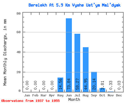
| Statistic | Jan | Feb | Mar | Apr | May | Jun | Jul | Aug | Sep | Oct | Nov | Dec | Annual |
|---|---|---|---|---|---|---|---|---|---|---|---|---|---|
| Mean | 0.00 | 0.00 | 0.00 | 0.00 | 14.56 | 73.84 | 58.26 | 44.94 | 20.14 | 3.81 | 0.33 | 0.03 | 215.11 |
| Standard Deviation | 0.00 | 0.00 | 0.00 | 0.00 | 11.12 | 32.59 | 18.26 | 19.86 | 9.92 | 2.35 | 0.28 | 0.06 | 44.18 |
| Min | 0.00 | 0.00 | 0.00 | 0.00 | 0.29 | 21.70 | 29.01 | 23.06 | 7.63 | 1.20 | 0.01 | 0.00 | 131.86 |
| Max | 0.00 | 0.00 | 0.00 | 0.00 | 36.75 | 152.64 | 91.25 | 99.68 | 43.34 | 9.97 | 1.18 | 0.23 | 288.37 |
| Coefficient of Variation | 4.24 | 0.76 | 0.44 | 0.31 | 0.44 | 0.49 | 0.62 | 0.85 | 1.89 | 0.20 |
 Return to R-Arctic Net Home Page