|
|
|||||||||||||||||
| Point ID: 8025 | Downloads | Plots | Site Data | Code: 1025 |
|
|
|||||||||||||||||
| Download | |
|---|---|
| Site Descriptor Information | Site Time Series Data |
| Link to all available data | |
| View: | Time Series | All |
| Units: | mm |
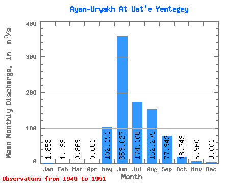
| Statistic | Jan | Feb | Mar | Apr | May | Jun | Jul | Aug | Sep | Oct | Nov | Dec | Annual |
|---|---|---|---|---|---|---|---|---|---|---|---|---|---|
| Mean | 1.85 | 1.13 | 0.87 | 0.68 | 102.19 | 359.03 | 174.11 | 152.28 | 77.94 | 18.74 | 5.96 | 3.00 | 78.48 |
| Standard Deviation | 1.17 | 1.01 | 0.83 | 0.65 | 74.72 | 182.39 | 95.43 | 109.67 | 42.56 | 11.70 | 2.84 | 1.65 | 26.03 |
| Min | 0.50 | 0.24 | 0.07 | 0.04 | 7.59 | 93.30 | 0.00 | 0.00 | 0.00 | 0.00 | 0.00 | 0.00 | 29.58 |
| Max | 4.69 | 3.61 | 2.90 | 1.84 | 251.00 | 725.00 | 372.00 | 431.00 | 125.00 | 41.10 | 10.40 | 6.14 | 118.02 |
| Coefficient of Variation | 0.63 | 0.89 | 0.95 | 0.95 | 0.73 | 0.51 | 0.55 | 0.72 | 0.55 | 0.62 | 0.48 | 0.55 | 0.33 |
 Return to R-Arctic Net Home Page