|
|
|||||||||||||||||
| Point ID: 8025 | Downloads | Plots | Site Data | Code: 1025 |
|
|
|||||||||||||||||
| Download | |
|---|---|
| Site Descriptor Information | Site Time Series Data |
| Link to all available data | |
| View: | Time Series | All |
| Units: | m3/s |
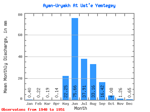
| Statistic | Jan | Feb | Mar | Apr | May | Jun | Jul | Aug | Sep | Oct | Nov | Dec | Annual |
|---|---|---|---|---|---|---|---|---|---|---|---|---|---|
| Mean | 0.40 | 0.23 | 0.19 | 0.14 | 22.25 | 75.66 | 37.91 | 33.15 | 16.43 | 4.08 | 1.26 | 0.65 | 201.38 |
| Standard Deviation | 0.25 | 0.20 | 0.18 | 0.14 | 16.27 | 38.44 | 20.78 | 23.88 | 8.97 | 2.55 | 0.60 | 0.36 | 66.79 |
| Min | 0.11 | 0.05 | 0.02 | 0.01 | 1.65 | 19.66 | 0.00 | 0.00 | 0.00 | 0.00 | 0.00 | 0.00 | 75.89 |
| Max | 1.02 | 0.72 | 0.63 | 0.39 | 54.65 | 152.78 | 80.99 | 93.84 | 26.34 | 8.95 | 2.19 | 1.34 | 302.82 |
| Coefficient of Variation | 0.63 | 0.89 | 0.95 | 0.95 | 0.73 | 0.51 | 0.55 | 0.72 | 0.55 | 0.62 | 0.48 | 0.55 | 0.33 |
 Return to R-Arctic Net Home Page