|
|
|||||||||||||||||
| Point ID: 8009 | Downloads | Plots | Site Data | Code: 3810 |
|
|
|||||||||||||||||
| Download | |
|---|---|
| Site Descriptor Information | Site Time Series Data |
| Link to all available data | |
| View: | Time Series | All |
| Units: | mm |
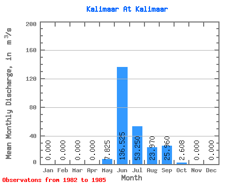
| Statistic | Jan | Feb | Mar | Apr | May | Jun | Jul | Aug | Sep | Oct | Nov | Dec | Annual |
|---|---|---|---|---|---|---|---|---|---|---|---|---|---|
| Mean | 0.00 | 0.00 | 0.00 | 0.00 | 7.83 | 136.53 | 53.25 | 23.97 | 25.96 | 2.61 | 0.00 | 0.00 | 20.84 |
| Standard Deviation | 0.00 | 0.00 | 0.00 | 0.00 | 15.65 | 73.57 | 29.02 | 14.71 | 19.14 | 2.52 | 0.00 | 0.00 | 5.37 |
| Min | 0.00 | 0.00 | 0.00 | 0.00 | 0.00 | 28.10 | 25.40 | 3.78 | 5.34 | 0.34 | 0.00 | 0.00 | 13.90 |
| Max | 0.00 | 0.00 | 0.00 | 0.00 | 31.30 | 192.00 | 86.10 | 38.80 | 45.70 | 4.90 | 0.00 | 0.00 | 25.99 |
| Coefficient of Variation | 2.00 | 0.54 | 0.55 | 0.61 | 0.74 | 0.96 | 0.26 |
 Return to R-Arctic Net Home Page