|
|
|||||||||||||||||
| Point ID: 8009 | Downloads | Plots | Site Data | Code: 3810 |
|
|
|||||||||||||||||
| Download | |
|---|---|
| Site Descriptor Information | Site Time Series Data |
| Link to all available data | |
| View: | Time Series | All |
| Units: | m3/s |
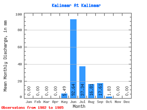
| Statistic | Jan | Feb | Mar | Apr | May | Jun | Jul | Aug | Sep | Oct | Nov | Dec | Annual |
|---|---|---|---|---|---|---|---|---|---|---|---|---|---|
| Mean | 0.00 | 0.00 | 0.00 | 0.00 | 5.49 | 92.64 | 37.33 | 16.80 | 17.61 | 1.83 | 0.00 | 0.00 | 172.22 |
| Standard Deviation | 0.00 | 0.00 | 0.00 | 0.00 | 10.97 | 49.92 | 20.34 | 10.31 | 12.98 | 1.77 | 0.00 | 0.00 | 44.33 |
| Min | 0.00 | 0.00 | 0.00 | 0.00 | 0.00 | 19.07 | 17.81 | 2.65 | 3.62 | 0.24 | 0.00 | 0.00 | 114.84 |
| Max | 0.00 | 0.00 | 0.00 | 0.00 | 21.94 | 130.28 | 60.36 | 27.20 | 31.01 | 3.44 | 0.00 | 0.00 | 214.72 |
| Coefficient of Variation | 2.00 | 0.54 | 0.55 | 0.61 | 0.74 | 0.96 | 0.26 |
 Return to R-Arctic Net Home Page