|
|
|||||||||||||||||
| Point ID: 7988 | Downloads | Plots | Site Data | Code: 3638 |
|
|
|||||||||||||||||
| Download | |
|---|---|
| Site Descriptor Information | Site Time Series Data |
| Link to all available data | |
| View: | Time Series | All |
| Units: | mm |
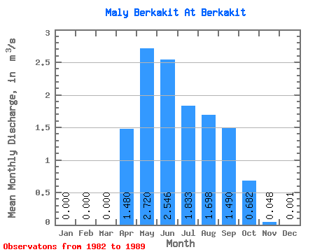
| Statistic | Jan | Feb | Mar | Apr | May | Jun | Jul | Aug | Sep | Oct | Nov | Dec | Annual |
|---|---|---|---|---|---|---|---|---|---|---|---|---|---|
| Mean | 0.00 | 0.00 | 0.00 | 1.48 | 2.72 | 2.55 | 1.83 | 1.70 | 1.49 | 0.68 | 0.05 | 0.00 | 1.02 |
| Standard Deviation | 0.00 | 0.00 | 0.00 | 0.99 | 1.06 | 1.31 | 0.86 | 0.84 | 0.64 | 0.14 | 0.04 | 0.00 | 0.26 |
| Min | 0.00 | 0.00 | 0.00 | 0.00 | 1.54 | 1.03 | 0.76 | 0.71 | 0.49 | 0.44 | 0.00 | 0.00 | 0.78 |
| Max | 0.00 | 0.00 | 0.00 | 3.09 | 4.51 | 4.39 | 2.89 | 3.50 | 2.38 | 0.84 | 0.12 | 0.01 | 1.38 |
| Coefficient of Variation | 0.67 | 0.39 | 0.52 | 0.47 | 0.50 | 0.43 | 0.21 | 0.87 | 2.00 | 0.25 |
 Return to R-Arctic Net Home Page