|
|
|||||||||||||||||
| Point ID: 7988 | Downloads | Plots | Site Data | Code: 3638 |
|
|
|||||||||||||||||
| Download | |
|---|---|
| Site Descriptor Information | Site Time Series Data |
| Link to all available data | |
| View: | Time Series | All |
| Units: | m3/s |
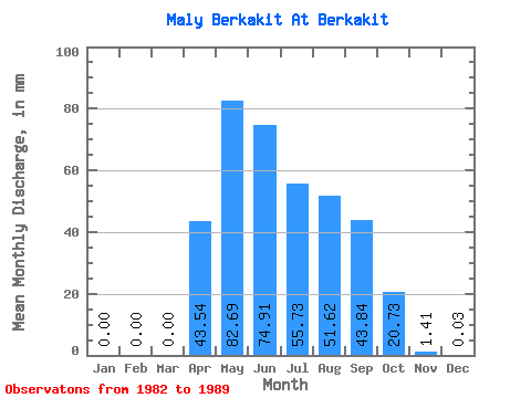
| Statistic | Jan | Feb | Mar | Apr | May | Jun | Jul | Aug | Sep | Oct | Nov | Dec | Annual |
|---|---|---|---|---|---|---|---|---|---|---|---|---|---|
| Mean | 0.00 | 0.00 | 0.00 | 43.54 | 82.68 | 74.91 | 55.70 | 51.60 | 43.84 | 20.75 | 1.43 | 0.04 | 366.45 |
| Standard Deviation | 0.00 | 0.00 | 0.00 | 29.05 | 32.36 | 38.57 | 26.18 | 25.62 | 18.79 | 4.29 | 1.24 | 0.08 | 91.86 |
| Min | 0.00 | 0.00 | 0.00 | 0.00 | 46.81 | 30.30 | 23.10 | 21.58 | 14.42 | 13.38 | 0.00 | 0.00 | 277.63 |
| Max | 0.00 | 0.00 | 0.00 | 90.91 | 137.09 | 129.16 | 87.85 | 106.39 | 70.02 | 25.53 | 3.53 | 0.15 | 493.22 |
| Coefficient of Variation | 0.67 | 0.39 | 0.52 | 0.47 | 0.50 | 0.43 | 0.21 | 0.87 | 2.00 | 0.25 |
 Return to R-Arctic Net Home Page